In short
Handy GPS is a tracking app for Android made by BinaryEarth. This is a great app for people. It helps to save battery.
Highlights
Very Good Tracking App
The Handy GPS app is the best thing I have seen
It runs perfect in Airplane mode with GPS on to save battery
Having grid refs is a great advantage over other gps apps
In addition a great phone app as well
Great app for doing geological field work
Works as well as my Garmin handheld
This is both a professional tool and a leisure gadget
Brilliant control of waypoints and breadcrumb trail
Support response has been excellent
Corrupted google maps and had to uninstall
So why waste money on it
With hideously complicated processes
You can't browse for certain locations such as lakes
If a simple feature cannot work how well do the others work
Also lost its fix on satellite's several times
Description
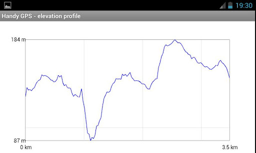
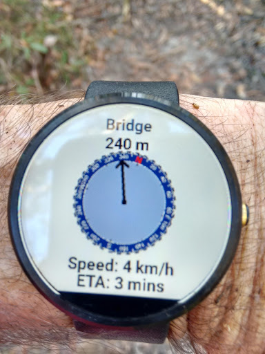
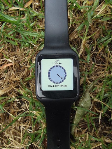
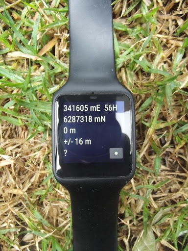
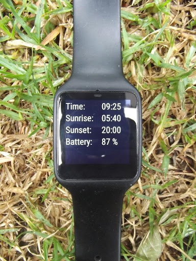
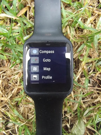
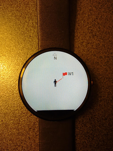
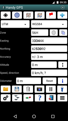
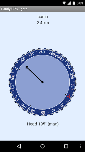
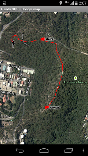
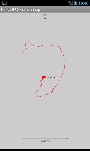
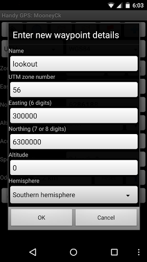
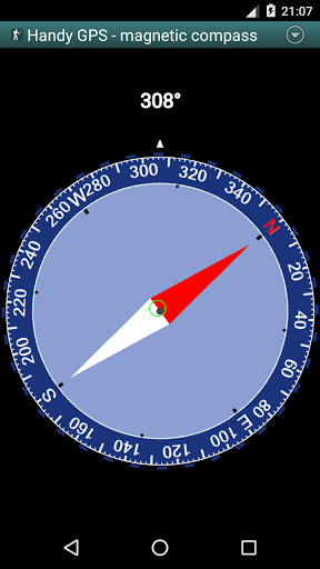
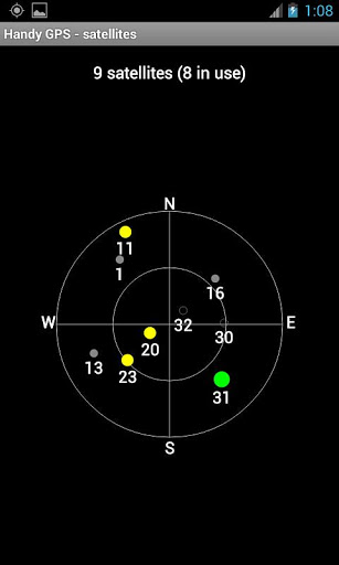
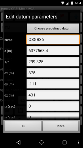
The perfect companion for your next outdoor adventure. Seek, find, record and return home with Handy GPS. This app is a real navigation tool designed for outdoors sports like hiking, bushwalking, mountain biking, kayaking and trail riding. It is also well suited to uses like mining, forestry, and archaeology. Its simple to use and works even in the remotest back country since it doesn't need network connectivity. It allows you to work in UTM or lat/lon coordinates so you can use it with your paper topographic maps. Waypoints and track logs recorded in the field can be be viewed later in Google Earth. BASE FEATURES: * Shows current location in easting/northing (UTM) or lat/lon * Shows speed, direction of travel, distance travelled in either metric or imperial/US units * Can store current location as a waypoint, and can store track logs * Waypoints and track logs can be imported from and exported to Google Earth KML and GPX files * Allows manual entry of waypoint coordinates in UTM, MGRS or lat/lon * Custom waypoint symbols * Can guide you to a waypoint with the "Goto"screen, with optional audible proximity alert * Has magnetic compass page (devices with mag sensors only) * Computes local magnetic declination and geoid correction at startup using the IGRF-12 and EGM96 models * Can display either a simple map of your current location and the stored waypoints, or a Google Map * Supports the world-wide WGS84 datum along with the Australian datums AGD66, AGD84, GDA94. (You can also use WGS84 for NAD83 maps) * Shows satellite locations and signal strengths graphically * Can display simple 6, 8 or 10 digit grid refs, or MGRS grid ref. * Waypoint-to-waypoint distance and direction * Optional timer to record walk duration and compute average speed * Can be used instead of "MyTracks"app * Thoroughly tested by developer on many off-track walks EXTRA FEATURES IN THIS VERSION: * Unlimited number of waypoints and track log points. (Free version limited to 3 waypoints and 40 tracklog points) * Email or SMS containing a clickable link showing your location can be sent to a friend. * Common datums such as NAD83 (US), OSGB36 (UK), NZTM2000 (NZ), SAD69 (South America) and ED50 (Europe) can be selected from the custom datum page, or you can configure your own datums, including local grid systems (such as those used at mine sites). You can also load and save datum params. * UK grid refs with two letter prefixes can be shown if OSGB datum selected. OSGB grid refs can also be shown on smartwatches. * Elevation profile of your route can be shown. * Average GPS locations over time to give more accurate result. * Take photos from the app which are optionally geotagged, or have the location "burnt"into image. * Show sun rise and set times. * Export waypoints to CSV file in current coordinate system. * Create a new waypoint by projecting an existing one using an entered distance and bearing. * Compute length, area, and elevation change for tracklog. * Offline map support by downloading tiles from map tile servers, or using your own map images. * Comes complete with an Android Wear version for use on your Android Wear smartwatch. PERMISSIONS: (1) GPS - to determine your location, (2) Network access - for access to Google Map and OSM tiles, (3) SD card access - to load and store waypoints and tracklogs, (4) Camera access for taking pics, (5) Prevent phone from sleeping so that proximity alarm works, (6) Control flashlight, to allow the flashlight to be turned on/off from within the app, and (7) System settings, to allow the Android Wear app to control the watch screen brightness. DISCLAIMER: You use this app at your own risk. The developer accepts no responsibility for you getting lost as a result of using this app. Batteries in mobile devices can go flat. An alternate power source is recommended for extended hikes. See the Coordinate Master app for support for more coordinate systems. Handy GPS is also available for iPhone and Windows Phone.
More