In short
US Topo Maps Free is a free Android android app from ATLOGIS Geoinformatics oHG. It is a great way to find ridge lines.
Highlights
This is the greatest android app I have ever downloaded
It really helped to find ridge lines
Best app for topo maps
The map selection is unparalleled
Handy app to have while traveling and camping end msg
The help section also explained every feature perfect
Having them free with gps capability is awesome
Good map for landscape detail and backpacking travel
Good app so far no bugs
Great app to have when navigating in the woods or mountains
Most time splices of maps did not match
Could not get to shut down so kept eating bandwidth and memory
Didn't even try to use the app cuz I was laughing to hard
It fails on two different phones
Description
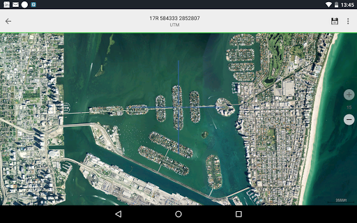
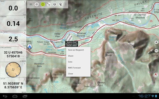
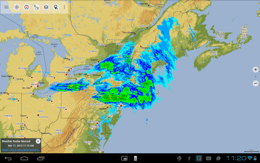
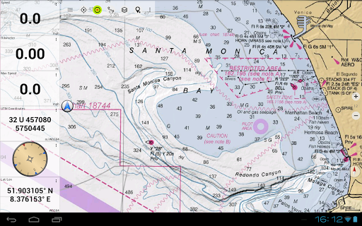
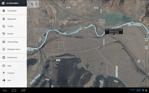
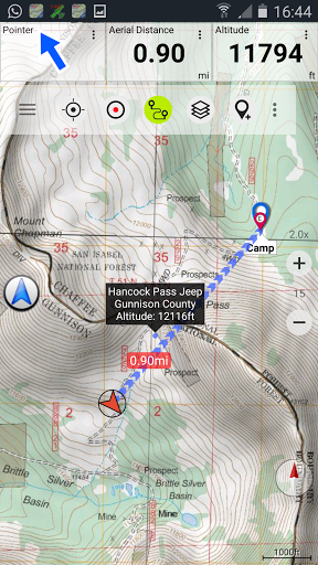
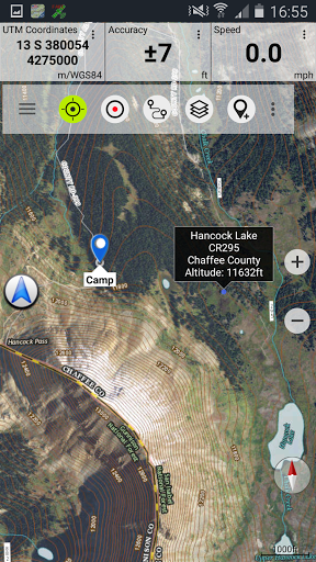
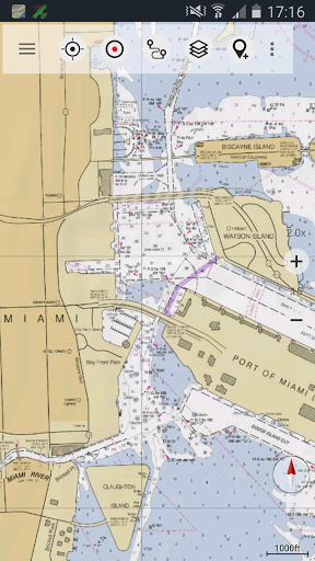
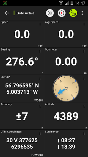
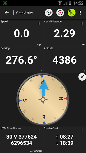
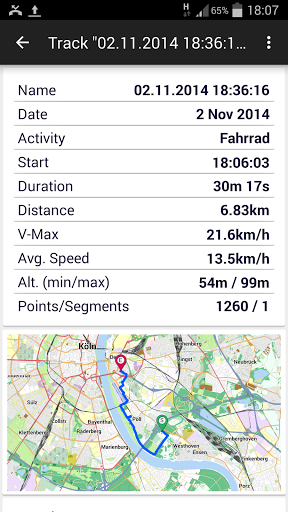
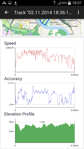
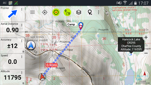
Easy to use outdoor navigation app with free access to the best topographic maps and aerial images for the USA. *** Please use USGS National Map or OSM if you need most recent maps *** Choose between >20 map layers (topos, aerials, sea charts, flight charts, ...) Turn your Andoid Phone/Tablet into an outdoor GPS for trips into the backcountry. This app gives you similar mapping options as you might know from Garmin GPS handhelds. Main features for outdoor-navigation: • Download of map tiles for OFFLINE USAGE (PRO-VERSION ONLY !) • Display Real-Time nowCoast Weather Information and NEXRAD Weather Radar • Free access to more than 100.000 seamlessly stitched USGS topographic maps - easy to use as browsable map layer • Create and edit Waypoints • GoTo-Waypoint-Navigation • Create and edit Routes (PRO only !) • Route-Navigation (Point-to-Point Navigation) • Track Recording (with speed, elevation and accuracy profile) • Tripmaster with fields for odometer, average speed, bearing, elevation, etc. • GPX/KML/KMZ Import/Export • Search (placenames, POIs, streets) • Customizable datafields in Map View and Tripmaster (e.g. Speed, Distance, Compass, ...) • Share Waypoints, Tracks or Routes (via eMail, Dropbox, Facebook, ..) • Use coordinates in WGS84, UTM or MGRS/USNG (Military Grid/ US National Grid) • Get NWS Weather Forecast • Track Replay • and many more ... Available map layers: • USGS DRGs: Seamless coverage of topo maps of the USA at Scales 1:250.000, 1:100.000, 1:63.000 and 1:24.000/25.000 • USGS High Resolution aerial imagery • USGS National Map • Orthoimagery for conterminous US • Google Maps (Satellite images, Road- and Terrain-Map) • Bing Maps (Satellite images, Road-Map) • Open Street Maps • Earth At Night • FSTopo Forest Maps • NOAA Nautical RNC Charts • Public Land Ownership (Padus) • Flight Charts Available map overlays: • Hillshading overlay layer for OSM, Google or Bing maps (PRO-VERSION ONLY !) • Ridge Weather Radar NWS • Wind, Temperature, Pressure • Wind Vectors • Precipitation Estimate - 1-hr • Precipitation Forecast 24h • Surface Air Temperature • Hazard Warnings • Tropical Cyclone Track • Wind Vector Forecast 24h • Max. Air Forecast 24h • Min. Air Forecast 24h USGS DRG topographic maps: The 7.5-minute maps (1:24.000/1:25.000) are the best maps for outdoor activities in the USA. Although some of the maps are quite old, they contain many small pathes and 4WD tracks that are missing in new USTopos, Google, Bing and OSM maps. New US Topo Maps: US Topo maps are a graphic synthesis of The National Map data files and are produced in the familiar 7.5-minute by 7.5- minute geographic format. Current US Topo map layers include an orthoimage base, transportation, geographic names, topographic contours, boundaries, hydrography and woodlands. Also included are the Public Land Survey System (PLSS) and the United States National Grid. NAIP Orthoimagery: Seamless coverage of contiguous US with 1m/pixel resolution HRO aerial imagery: High resolution arial photos covering US urban areas & borders (up to 10cm/pixel) Use this navigation app for outdoor activities like hiking, biking, camping, climbing, riding, skiing, canoeing, hunting, snowmobile tours, offroad 4WD tours or search&rescue (SAR). Add custom waypoints in longitude/latitude, UTM or MGRS/USNG format with WGS84 datum. Import/Export/Share GPS-Waypoints/Tracks/Routes in GPX or Google Earth KML/KMZ format. (PRO-VERSION ONLY !) View Real-time nowCoast weather information like temperature or windvectors and overlay to map. See animated NEXRAD rain radar to make accurate predictions when raining will start/stop (PRO-VERSION ONLY !). LIMITATIONS OF THIS FREE VERSION: • Ads • No Bulkdownload • No new) US-Topos layer • No Hillshading overlay • Max. 3 Waypoints • Max. 3 Tracks • No Routes • No import of waypoints and tracks • No Local City DB (Offline Search) Please send comments and feature requests to usmaps@atlogis.com
More