In short
HUNT App: Public/Private Lands & Hunting GPS Maps is a free iOS hunting app from onXmaps, Inc.
Highlights
Hands down the best hunting app on the market
It's amazing to see where this app
This is the most useful hunting app I have ever seen
Thanks for providing it for us
This is truly a game changer
The only downfall is that I have noticed
No response no help to correct the issue
Also it is very hard to cancel the membership
The compass feature is awful
And the entire app freezes
Description
The New Era of GPS - Use the HUNT App as a fully functioning GPS on your phone. View private and public land ownership, hunting units, roads and trails, real-time weather and much more! Turn your phone into a dedicated GPS with offline saving, tracking, and more!
Voted the #1 Hunting App by Game and Fish Magazine and used by over 1,500 State Game Wardens and other government employees. The HUNT App has been featured in Field and Stream, Outdoor Life, American Hunter and other magazines as a must have tool for any hunter.
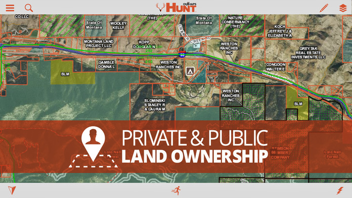
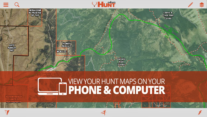
Use the HUNT App combined with the GPS in your iPhone or iPad to view hunting specific map layers, while knowing your location relative to public and private property boundaries. HUNT Smarter with the confidence you are using the most accurate, up-to-date, reliable & most trusted land ownership maps available! Scout at home, find new propertie, plan your hunt, then head out to your new favorite stand.
FREE FEATURES
•NO ADS
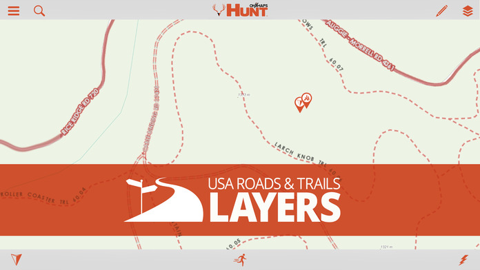
•Aerial Imagery, 24K Topo maps & many more Basemaps
•Hunting Units or Game Management Units (GMU) for general game species in all 50 states. (for example, in Wyoming you will see Antelope, Deer, & Elk)
•Mark Waypoints with icons or photos to help you navigate back to your vehicle, camp, or hunt stand.
•Easily measure distances between treestands & blinds.
•Measure Acreage with the Shape tool to easily measure food plots.
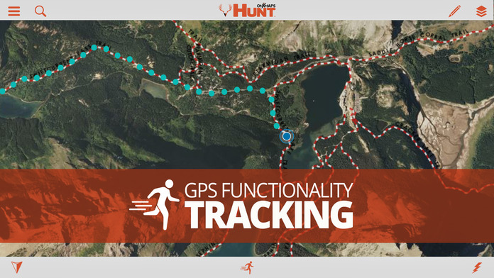
•Track the distance, duration and speed of your hunt with tracking.
•Complimentary mapping layers.
•Points of Interest & Geographic Features.
FREE TRIAL
While the HUNT App & many of it’s features are free. You will also start a free Premium State Membership trial when you install the App. This allows you to try our full featured State Membership for 7 days.
PREMIUM STATE MEMBERSHIP FEATURES
Yearly State Memberships cost 14.99-34.99. By purchasing a state membership gain access to our proprietary maps developed by our GIS team. Get the same great features of the free HUNT App but with the additional benefits of:
•Public land like Forest Service, BLM, Wildlife Management Areas, State and County land, Timber Lands, & more!
•Landowner names with property boundaries in available counties*
•Search by landowner name to scout & look for new areas to hunt.
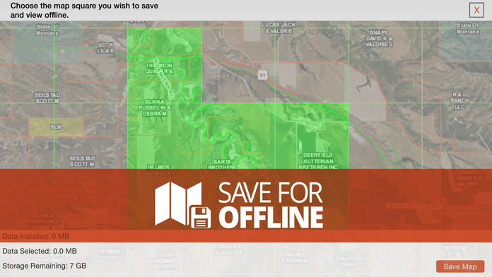
•Save maps for use when you are out of cell phone coverage.
•GMUs or Hunting Units for multiple species (In Wyoming you will see Antelope, Bighorn Sheep, Bison, Black Bear, Elk, Moose, Mountain Lion, Mule Deer, Mountain Goat, Turkey, White Tailed Deer, & Wolf)
•Possible Access Lands, Walk-In areas, Block Management Areas & private lands open to the public.
•Nationwide Road & Trails
•Section Lines & Numbers
*Private landownership information may not be available for all counties. View the Complimentary county layer on the Map or visit our website.
MANAGE SUBSCRIPTION
•Turn off auto-renewal via the main Settings app: https://support.apple.com/en-us/HT202039
•Subscription automatically renews unless auto-renew is turned off at least 24-hours before the end of the current period. Your iTunes account will be charged for renewal within 24-hours prior to the end of the current period, & identify the cost of the renewal.
•Payment will be charged to iTunes Account at confirmation of Purchase.
•Visit the following URL for full terms of use: http://www.onxmaps.com/tou
GPS FUNCTIONALITY
The HUNT App uses the GPS built into your iPhone or iPad to display your location on the map. Cellular network coverage is NOT needed to use this app & the GPS functionality. Tile saving technology allows you to save basemaps & layers for use when you are out of cellular network coverage.
*Continued use of GPS running in the background can dramatically decrease battery life.
UPDATES
As land ownership and maps change we update the data on our servers which will automatically load the new maps to the HUNT App without you having to do anything!
FEEDBACK
Having a problem, or want to request new features please contact us at support@onxmaps.com
More