Highlights
This is really an amazing app using google maps
My only negative would be that I've contacted tech support a lot
Great way to track fishing spots and routes
I would like to thank the developer for such a great app
I definitely recommended this to friends
Depth and graph charts are excellent
Great work guys cheers
Very easy to download enc charts
Very handy to a back up of the boats gps
Its instant customer support are also helpfull
Down side is the upgrade process which is very unclear
App doesn't allow me to purchase a chart
Not buying any more map tiles if there are blank ones
All other tiles were completely fuzzy and unreadable
I consider this a major breach of my privacy
Description
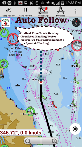
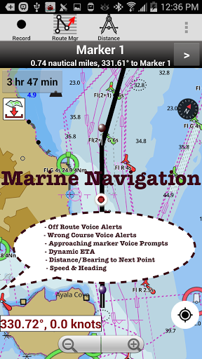
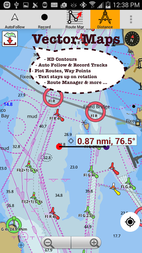
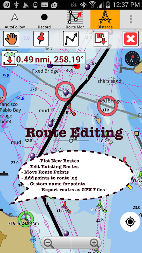
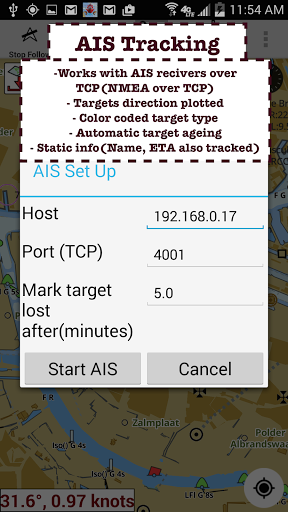
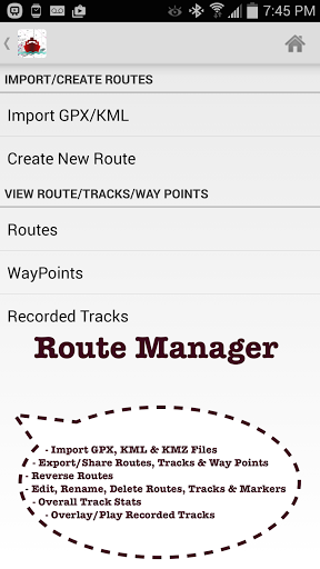
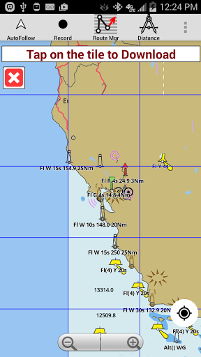
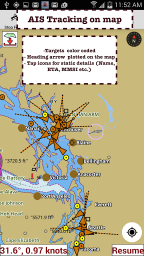
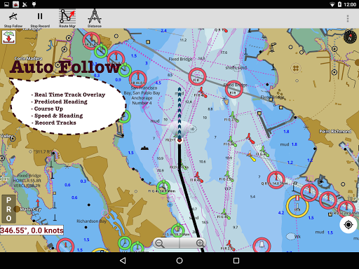
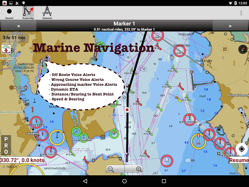
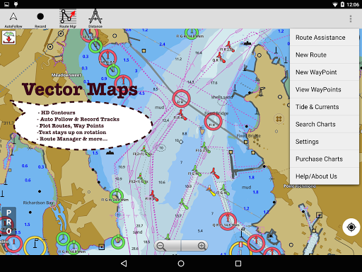
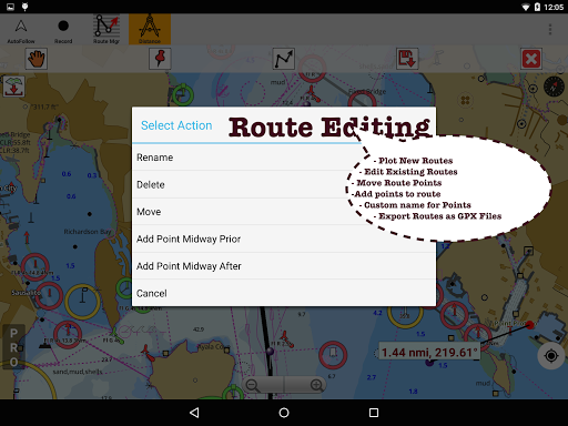
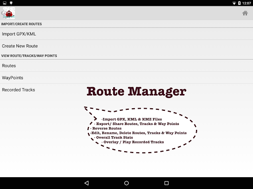
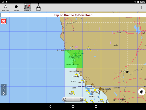
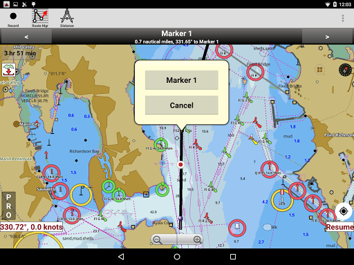
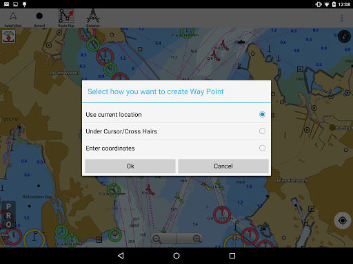
This Marine Charts App offers offline nautical charts, inland river navigation charts, and lake depth maps for kayaking, yachting & sailing. First marine GPS app to have route assistance with Voice Prompts for marine navigation. Create new boat GPS routes / Fishing Spots, or import existing GPX/KML routes on device. It supports Nautical Charts course up orientation. Incl Tide & Currents prediction. All features of a Marine Chartplotter. FEATURES √ Beautiful & detailed Hardware/GPU accelerated offline vector marine charts (text stays upright on rotation) √ Query details of Maritime Aids to Boat Navigation (Buoy, Lights, Obstruction,Marina etc) √ Custom depth shading of safety depth & units(Ft/Fathom/Meter/km/mi/NM) √ Record marine GPS tracks, Autofollow with real-time track overlay √ Voice Prompts for marine navigation (needs GPS ) √ 1ft / 3ft depth contour maps for anglers for selected lake maps. Useful for fishing/trolling(freshwater/saltwater). √ GPX/KML for boat GPS route mgt. √ Tide & Currents. √ Seamless marine chart quilting: Map details from Coastal, Approaches,Harbour,Inland Encs(rivers),and general ENC (Electronic Marine Charts) √ Waypoints support. MAPS All the details of your marine chartplotters! Incl. unlimited updates for 1 year. USA: Maps incl coverage of all NOAA marine charts,ENC,USACE inland river maps & freshwater lake fishing maps for more than 10K lakes. Charts incl HD/1ft/3ft bathymetry for selected lakes. Also incl NOAA marine charts(rasters) where NOAA ENC coverage isn't available. Canada: CHS data Incl Great lakes(US & Canada sides),Alberta & Ontario lakes,Lake Simcoe&Trent Severn Canal,Quebec reservoirs. UK/Ireland: UKHO marine charts Germany:BSH charts,Waterways & rivers. France Europe Inland Rivers:Donau/Danube/Dunaja,Rhine,Rhein,Garonne,Moselle,Drava,Sava Australia Netherland/Holland Croatia Finland Norway Sweden Russia Ukraine(Black Sea) Brazil Spain Malta,Cypress & Mediterranean Sea Caribbean New Zealand Denmark,Greenland,Faroe Seychelles,Mauritius,Tanzania Falklands Malaysia,South China Sea Persian/Arabian Gulf,Red Sea South Africa Argentina Iceland Fiji Estonia,Latvia,Poland,Lithuania Turkey,Greece,Italy Instrumentation √ Marine AIS & (NMEA AIS and GPS over TCP/UDP) √ Wind direction & Speed,Marine Sonar depth,Water temperature ROUTE MANAGEMENT / TRIP PLANNING √ Create/Edit/Reverse Boat Routes √ Waypoints mgt √ Import GPX,KML & KMZ files √ Share/Export Routes,Fishing Spots,Tracks&Markers GPS FEATURES for BOAT NAVIGATION √ Auto Follow * Real Time Overlay & Predicted Path Vector * Course Up * Speed & Heading √ Route Assistance With Voice Prompts * approaching boating route marker prompt * Continuous distance & ETA updates * sailing/boating off route/wrong direction alerts. √ Record Tracks TIDE & CURRENTS * US,Canada,UK,Germany,Norway,Australia &New Zealand * High/Low Tides * Tidal Current Prediction * Active Current Stations SHARING * Sharing of tracks/Boat routes/markers/Fishing Spots * Export GPX files. Change background to Satellite Imagery USA Marine Charts * Texas Fishing : Lake Texoma,Eufaula,Toledo Bend * Florida Fishing: Lake Okeechobee,Kissimmee * Minnesota Fishing: Lake Minnetonka,Waconia,Leech,Mille Lacs * Massachussets lakes Quabbin * Ohio Fishing maps of Lake hoover * Wisconsin Fishig: Lake Winnebago,Pepin * Utah Lake Powell,Bear * Maine Lake Sebago * Alaska Fishing: Lake Winnipesaukee * Tennessee Lake Barkley,Norris,Watts Bar * South Carolina Lake Keowee,Hartwell,Murray * Lake Michigan,Huron,Ontario,Superior,Erie Canada Fishing Maps * Lac Saint Jean * Fishing maps of Ontario Lakes * Rideau Canal-Ottawa River * British Columbia Marine Charts * Pacific Coast-Vancouver- Haida Gwaii * Nova Scotia South- Bay of Fundy * Quebec to Anticosti Island * Newfoundland * St. Lawrence river * Manitoba & Saskatchewan * Georgian Bay * Puget Sound UK Fishing Maps * Scotland * Thames Estuary * Ireland Australia fishing Maps * NSW South West Rocks * Queensland Hervy Bay
More