In short
iFly GPS is a free Android flight app from Adventure Pilot, LLC. It is a great way to see implementation.
Highlights
Best user interface I've seen on an EFB
I am impressed by the quality and user friendly interface
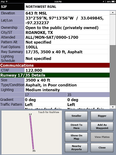
Quick access to airport info including fbo and fuel prices
The app has been very stable on my Android tablet which is important
But I think it's the bast aviation app on android
And provides me a great tool for quick flight planning
They are extremely responsive and keep adding new features
The winds aloft and flight optimization is so cool
Great customer service
This is the best pilot EFB I have seen yet for the Android
Locks up and reboots device all the time
Unable to download charts
Not their developers' job simpler
Still no response after a few weeks
We will not be back a 3rd time just to be disappointed
Description
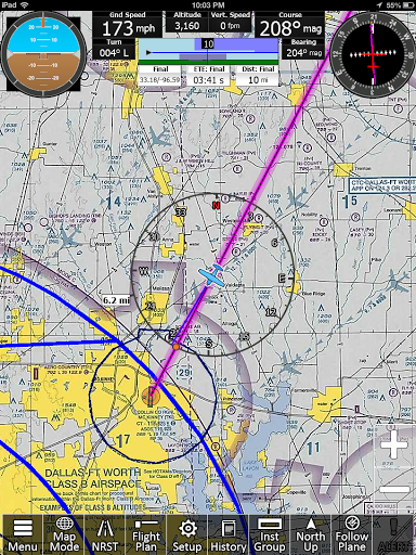
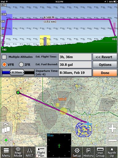
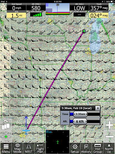
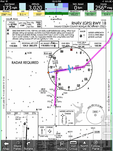
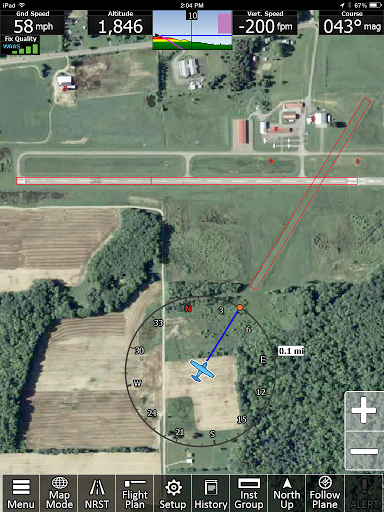
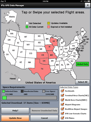
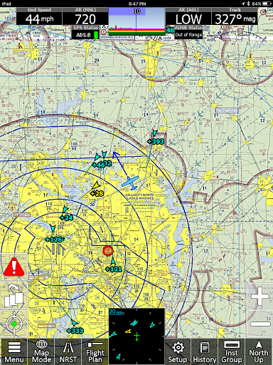
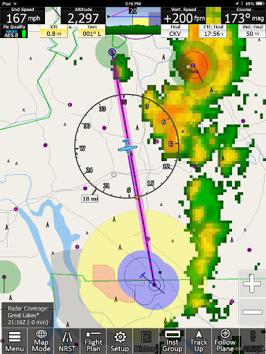
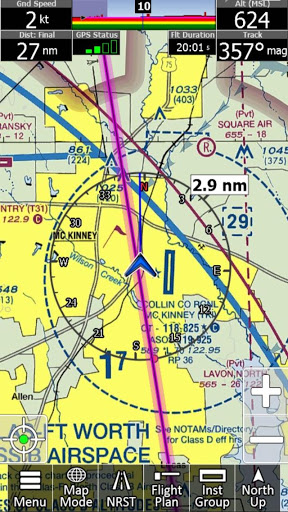
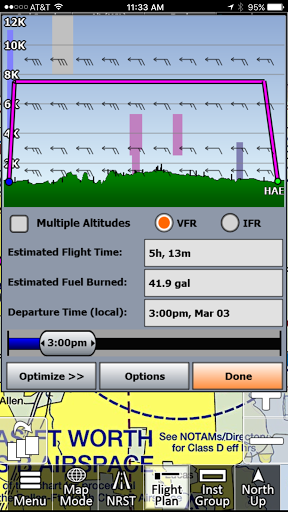
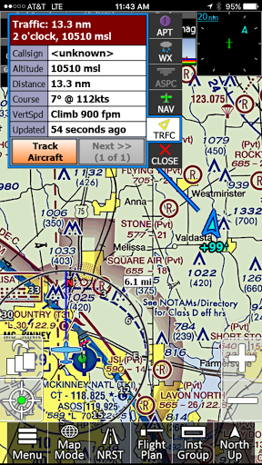
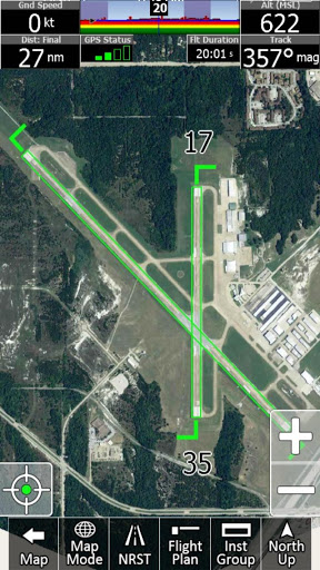
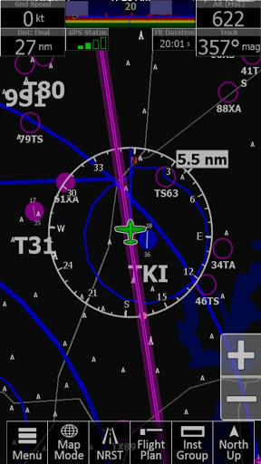
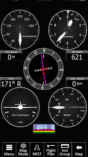
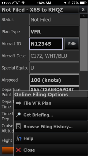
iFly GPS for Android. It’s Simply Amazing: iFly GPS delivers the perfect combination of affordability, capability, and usability for both VFR and IFR Pilots. Safely and quickly get the information you need so you can focus on flying! Designed by Pilots, Tested by Pilots and Recommended by Pilots: iFly GPS for Android was built on the knowledge and experience from our line of dedicated aviation hardware, and a collaborative user experience based on feedback from thousands of fellow pilots. Free 30-Day Trial: Enjoy a free 30-day IFR/VFR subscription, and see how iFly GPS provides you with what you need for aviation. Requires: Android 4.0.x or higher, plus 500 MB data storage. Affordability for All: Enjoy comprehensive and simple updates with affordable subscriptions for only $69.99 VFR or $109.99 IFR/VFR per year. Existing iFly device subscribers can extend their subscription to their Android for only $19.99. Feature Highlights: Flight Planning with an intuitive interface allowing for simple building of direct-to or multiple waypoint flight plans directly on the FAA, Vector charts or the Flight Plan page. Set a departure and destination, and then customize your path with the rubber-band feature. Active Alerting System from Airspace Alerts to Collision Alerts, our Active Alerting System provides a central location for Alerts and more. RealView Airports provides satellite imaging of 12,600+ Airports for pilot reference and our AutoTaxi+ feature. Have a visual knowledge of the airport before arrival. AutoTaxi+ transitions to the Airport Diagram upon landing or from Taxi Diagram to Chart Mode upon Take-off. You Android will use the RealView image as a taxi-diagram if an official FAA Diagram is nor present. See your position on over 12,600 airports! Instruments Page simulates real aircraft instruments, gathering information from GPS (or an attached 3rd party AHRS) to create familiar images. Reference instruments such as HSI, VSI, Groundspeed, Altimeter, Turn Indicator, etc. Add an AHRS and get an Artificial Horizon with Attitude Safety Alerts. VFR / IFR Data is included, complete with US geo-referenced Sectionals, TACs, Low-Enroute, Approach Plates, Airport Diagrams and much more. Everything from flight planning to flying is designed around image-enhanced charts from the FAA. Geo-Reference Approach Plates and Airport Diagrams provide pilots with actual FAA Approached and Airport Diagrams beautifully represented. Public / Private Airports using official databases for both Public and Private airport information. Databases update directly from the FAA Data Cycles. Create your own Custom Waypoints for those locations that are not on the charts or maps. Pre-Flight Weather provides an interactive map with graphical VFR/IFR visuals and allows for touch reporting of METARS, TAFs and Winds Aloft at your fingertips. ADS-B Weather / Traffic - iFly GPS for Android supports connection to third party ADS-B devices including iLevil, NavWorx, Dual, SkyGuardTWX, Clarity, or SkyRadar and more for free Weather and Traffic. KEY FEATURES: -Moving Map Modes • VFR (Sectionals, WAC, TAC) • Low/High-Enroute Charts • Vector Base Map • Plates & Diagrams (Approach, Departure, Stars) -Dynamic Map Overlays • Weather and Nexrad (Pre-Flight or ADS-B Live) • Terrain and Obstructions • Fuel Prices • Approach Plates -Instruments Panel -Day/Night Mode -Instrument Layouts (with over 24 Instruments including HSI, Vertical Profile, and AHRS) -Fly Direct-To -Vertical terrain planning and Airspace preview -Save/Load Flight Plans and Waypoints -Find Nearest -History -North Up / Track Up -Pinch Zooming w/ One Touch Feature -Map Settings • Distance Circles • Dynamic Distance Ring • Hybrid Compass Rose w/ Nav Function • Extended Course Line • Flight Trails • Past Flights • Rubber Band route modification • Custom Aircraft icons • AutoTaxi+ -Alerts & Warnings -Button Fading -Custom Waypoints -Customizable Instruments -Simulator Mode
More