In short
Boating Asia&Africa is an Android navigation app from Navionics.
Highlights
Great Apps for the price compatible with even China phone n tablet
The best navigation app out there
This is the best marine gps application
Keep on nav com wish u the best
This is a handy application
But over all its a great app
Just wondering how reliable is the hong kong sonar charts
My favourite application for marine navigation
The most accurate positional app
It doesn't have any negatives and I'm a very happy customer
Keep hanging the phone and crashing is ridiculous
After latest update unable to open app
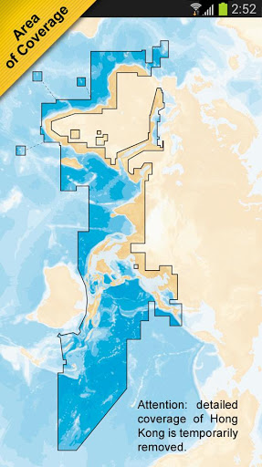
It is very inconvenient not to have a Hong Kong chart
Lost manr whay points
Description
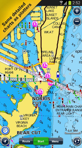
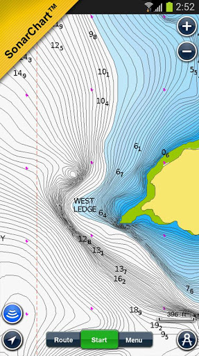
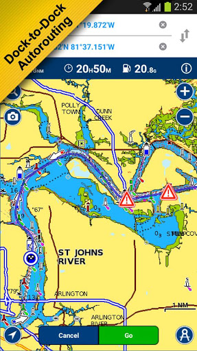
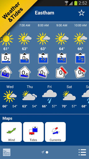
The world's most popular marine & lakes app! A favorite among cruisers, sailors, fishermen and divers. Find the same detailed charts as on the best GPS plotters. This app includes the overwhelming value of Navionics+. Alternatively, you may have found a free version on the store offering basic features, where Navionics+ can be purchased In-App. If you have a tablet, please search our HD app. NAVIONICS+ includes: √ Download of the following chart layers that will reside on your device even after expiration: -NAUTICAL CHART for all essential cartographic reference detail. The most accurate and thorough set of information based on Hydrographic Office data, Notices to Mariners, new publications, our own surveys, and reports from users. It provides port plans, safety depth contours, marine services info, tides & currents, navigation aids and more. -SONARCHART: the award-winning 1 ft/0.5m HD bathymetry map that reflects ever-changing conditions. Be part of the community and contribute by uploading your sonar logs to enhance it. -COMMUNITY EDITS made by users (rocks, wrecks, etc.) and shared for all to benefit. √ CHART UPDATES: we deliver more than 2,000 updates every day! Take advantage of our updates as frequently as you like. √ DOCK-TO-DOCK AUTOROUTING quickly creates detailed routes even through narrow waterways and channels, based on chart data and navigation aids. POIs are automatically shown nearby your destination. √ NAVIGATION MODULE for advanced route planning with ETA, distance to arrival, heading to WP, fuel consumption and more! √ ADVANCED MAP OPTIONS: overlay Satellite/Terrain, highlight Shallow Areas, filter Depth Contours and enable a Fishing Range to target key fishing areas. √ PLOTTER SYNC - Compatible Wi-Fi enabled plotter owners can transfer routes and markers, activate and update their eligible plotter card and upload sonar logs for improved SonarChart! Learn more at www.navionics.com/en/plotter-sync √ WEATHER & TIDES provides real-time weather data and forecasts. Access daily and hourly forecasts for your favorite locations and get wind, weather buoys, Tides & Currents overlaid on your map. Buoy data from NOAA can include wind speed, gust and direction as well as air pressure, water temperature, wave height and other relevant marine data. Note: Download detailed maps by zooming in or from Menu>Download Map. Check navionics.com for coverage. Navionics+ is a one year subscription. At expiration, you can renew with a discount of up to 50%. If you don’t renew, you can still use the charts you previously downloaded, along with several free features: TRACK your journey, view speed, distance, time and COG. ROUTES: create and edit, based on speed and fuel consumption Measure DISTANCE, add MARKERS, get WIND FORECASTS and sun/moon cycles MAP OPTIONS: adjust shorelines to selected Water Level, choose Depth Shading and Easy View (not on Govt. Charts) SYNC Tracks, Routes & Markers among your mobile devices MAGAZINES & GUIDES for location-based articles. GOVT. CHART in US SONARCHART LIVE - allows you to create new personal 1ft/0.5 m HD bathymetry maps that display in real time while navigating. Upload your sonar logs to build even better local charts for your area connecting wirelessly to a compatible sounder/plotter. COVERAGE: Detailed coverage of Hong Kong is temporarily removed. Navionics has certified several Android models where the app is designed to load and operate correctly with an OS of 4.0 or higher. Please refer to our Compatibility Guide, which is continuously updated at http://www.navionics.com/en/compatibility/mobile. We cannot guarantee flawless operation or provide support for non-certified devices. ALL SALES ARE FINAL on Google Play.
More